I’ve said it once and I’ll say it again, if it wasn’t directly in the shadow of Mount Rainier, the Tatoosh range would be it’s own National Park.
The gate into the park was a little late, opening at about 9:30am. We drove from Longmire up to Narada Falls under a nearly cloudless sky. Crossing the Nisqually bridge we considered skiing the Nisqually Chute but instead stuck with our original plan to head towards Lane Peak.
From the parking lot there was obvious debris on the apron below the Fly and Zipper couloirs from what was likely loose-wet activity the day prior. Considering the northern facing aspect, it looked like there was potential for crusty conditions but the trees were holding good snow and skinning up to Stevens Canyon Road from the falls we found light powdery snow that we were hoping for reassuring us on the conditions.
At this point in the season Stevens Canyon Road has been plowed so we threw the skis over our shoulder for the short walk to the bend were we transitioned and rode the trees down to Tatoosh Creek trending west toward the base of Lane Peak.
Now the clouds came in on what had been blue sky all morning and it began snowing heavily. Crossing the creek we passed a group who was bailing due to avalanche concern. We continued on, following the skin track of an another group who appeared to be heading for the adjacent Fly Couloir.
Up until this point we had not committed to a specific objective, instead keeping an option open to ski either the Fly or the Zipper Couloir. At the tree stand that sits where the base of the two couloirs meet we decided to boot up the Zipper, being the steeper and narrower of the two as the group ahead of us was going for the Fly.
The climbing started out in thigh deep snow making for slow going, however as we ascended the booting eased up. As we climbed the snow began to warm and drop off the tree branches on the walls above. As the trees bombed the couloir the snow would pick up speed and mass flushing the slope we were on and creating significant loose-wet slides that could easily take you off your feet. We picked up our pace to minimize our time in this hazard zone and finally finished the remaining 500ft of the couloir by 1:30pm with no major incidents.
This time of year the gate is closing at 4pm and not wanting to get stuck in the park we hurried our transition to drop in. The day was still warming as well and the wet slides in the couloir were increasing in their frequency and volume. We skied the length of the couloir one at a time to reduce our exposure.
The turns in the couloir itself were incredible. The snow was soft and loose. A little too loose as sluff mitigation was critical after almost every turn. The apron had a lot of debris on it and made for some chunky skiing in spots. After this the snow warmed significantly slowing us to a crawl by the time we returned to the creek.
From here it was back up to the road and then a ski down to the car. We hit the gate at 3:50pm just before close.
We got lucky with the conditions. The skiing was great but the avalanche activity due to late spring sun on a northern aspect was much more than we anticipated. As is often the case it became a matter of timing. We got up and down without issue but any later in the day and we would have surely experienced significant hazard. Either way, another amazing ski line in Mount Rainer National Park.
This season has been fickle so far and there have been very few windows of favorable conditions.
After a decent storm that set down 25″ over the weekend, the clouds cleared and Presidents Day offered us one of those weather windows.
Bish and I met a the new market at 11:30am with the intention of going up Mt Snoqualmie and finding something to ski. Starting from Alpental and noon, we set a skin track up the Phantom slide path until we ran into another track that we followed up the South shoulder to the summit.
South Shoulder with Red Mountain in the background
Once up top, we took a look down the Slot but it had already been skied pretty good by that point in the day and it was looking chewed up. Instead we decided to ski the crooked couloir off the summit which was much broader with fewer tracks.
Top of Mt Snoqualmie, looking into the Crooked CouloirThe entrance
The entrance into the top was steep and required a little billygoating to get into but after that it opened way up for some nice deep turns all the way down to the choke. At the choke the couloir takes a 45º turn left and tightens into what can sometimes take the form of an ice buldge. Today it had been scraped by other skiers but the coverage was good so it was easy to maneuver.
This placed us out on the apron of the Slot that we skied down into Thunder Creek Basin to about 4600′. Here we transitioned and split back up to the notch getting to the top at 5pm. We skied down the front side and made it back to the car just before sunset.
In the week it took me to write this it has snowed another 1.5′ and then rained 5″ on top of that so once again everything is toast. Get it when you can.
I just moved back to Washington from Denver and I was psyched to get out in the North Cascades on return.
I met Byron at the Mt Baker Ski Area on Friday evening and we camped out so that we could have a leisurely start Saturday morning. The road is currently closed up to Artist Point at the Heather Meadows Visitor Center, or Grandma’s Hut as I’ve know it to be called. This added only a small amount of milage/elevation to our destination for the day, the White Salmon camp just below Winnies Slide.
We started at 10:30am and made it to Lake Ann by noon. It was a warm day and we stopped by the lake to have lunch before starting up the trail toward the Chimneys.
The trail past Lake Ann is well established and there are a number of good camp sites about 5-10 minutes down the trail just before the creek crossing. After that the path switchbacks up steeply for a ways and crosses a talus field just before entering the first of the chimneys.
There were a number of groups climbing that day so it wasn’t difficult to see the route from a distance but even without other folks to follow, the path seemed to be well established. We made it to camp just before 4pm.
The next morning we started our climb at 6am. The lower bivy site didn’t have a great water source so we climbed Winnies Slide, the first steep snow pitch, up to Camp 2 where there was a good flow coming out of the Upper Curtis Glacier. We filled our water bottles and then started onto the snow.
The glacier was in great shape and travel was straightforward with minimal obstacles to navigate. We climbed the Hourglass, the second and final steep snow pitch, before traversing on to the Sulphide Glacier. The upper stretch of the Sulphide was also in good shape and we climbed it up to the based of the South East Ridge on the summit block where we took a brief break before starting our climb on the ridge.
There are a couple of notches you can start the ridge climb from. We chose the further right and slightly deeper notch which resulted in some light down-climbing after the first pitch. This put us at the saddle of the second notch. We simul-climbed the route in 3ish blocks. It is mostly 3rd class with a few steeper but unsustained low 5 moves.
We summited at 10:30am and turned around quickly to start the long slog back to the car. We down climbed via the gully which was ultimately going to be much quicker than waiting around to rappel it. The gully down-climbed no harder than 4th class.
Both snow pitches we rappelled on fixed deadman that had been buried at the top of both Hourglass and Winnies. We made it back to our camp at 2pm. A nap was the vibe at this point so we took a brief one then packed up and walked out of camp around 3:30pm
The climb down the chimneys with our overnight packs wasn’t too tricky. The first two “pitches” off the ridge were the most sustained 4th class and it seemed to ease up after that. We were able to down-climb the whole thing without any additional rappels. I think we hit the lake at 6pm, only 4 more miles to go.
Things slowed down for us after this, finally we got to the cars at 8:40pm. Just under a 15 hour day. Not too bad. It’s nice to be back in the Cascades.
The county plowed the road to 4th of July campground on Thursday so we got up early Saturday morning to go ski Skywalk Couloir before the weather turned to rain for the weekend.
It has been a grey and wet spring in the Front Range. The forecast for Memorial Day weekend, starting around noon on Saturday, was thunderstorms and heavy precipitation through Monday, but there was a short window of sun Saturday morning that looked like we could squeeze something in. We started from the trail head at 4th of July campground just before 7am and hiked up a trail that was equal parts dirt and snow.
Nice day!
It took an hour to get up to the base of the couloir at 11k with the skis on our backs. Here we transitioned briefly to skins and split for a few hundred vert before strapping up the crampons and throwing the boards back on our packs. We also saw a moose here which was cool.
Once you are in the couloir starting about 11,800 it has a pretty consistent pitch of 45°, ramping up to 55° at the very top. Although it faces south southeast, the walls shield it so it stays shaded until later in the morning. Because of this it was just starting to warm as we climbed softening the snow gradually but preserving it well for climbing.
David taking a breather on the climb
I believe we finished on the Princess Leia variation (direct) but I did not see where the alternative or standard finish went. At this point the clouds were moving in and we were beginning to hear thunder in the distance. We transitioned and dropped back in on skis just before 11am, retracing our climbing line.
By the time we started skiing, the snow had softened giving nearly perfect top to bottom conditions. While the crux is at the top, the whole thing is a steep ski for 1500ft that doesn’t ease up until the apron.
Will skiing midway down Skywalker
At the bottom we threw the boards back on our packs and hoofed it out, getting back to the car just before 1pm and right as the first big drops oof rain started to fall. Just barely snuck it it.
There’s a good chance that any climb requiring a canoe approach is going to be a good one, however, first we had to get the boat in the water. On a busy Saturday morning in July this proved to be the crux of the trip. After circling the String Lake parking lot for 20 minutes we ultimately found a spot to park the cars where we could gear up and get in.
So we finally set out on String Lake around 11am, paddling most of its length until we got out at the north end and portaged to Leigh Lake. From here we paddled past Boulder island arcing around the peninsula and straight toward the major gully in the middle of Mt Moran that terminates as an apron on the lake.
The canoe took about an hour total and it was a warm day in the end of July so after we pulled the boat out of the water we took our time to jump in and swim out to a small island of rocks just out past the shore. Finally, we geared up and began hiking the rough trail as it climbed directly up the mountain.
Down low the trail that was primarily a rock hop turned into small stretches of gravely paths first on one side, then the other in order to skirt various obstacles. Eventually the trail cuts left on to a small slab to bypass a waterfall and then cut back right to continue the loose path.
Rock hop with the East and West Horns in the background
The trail was pretty unforgiving and after jumping back and forth a few more times it finally cut hard left near 8800ft. We passed a “closed for restoration” sign below a high meadow and followed it as it wound up the cliff bands to our left. We arrived at camp at 3pm exactly 2 hour after leaving the lake.
CMC camp is at 9600ft and made up of no more than 8 “sites” for a tent. There is a spring nearby and the trees that enclose camp make for a nice wind break. Above the camp proper there are 3-4 more sites the highest being just above 9800ft and directly below were the scramble begins for the approach, however these camps do not have the same access to water as the lower sites do.
The Grand from camp
Multiple trip reports advise scouting the next days approach prior to attempting it in the dark hours of the morning, so we spent the afternoon scrambling the rock ledges directly above camp looking for the path of least resistance. In the light the route finding wasn’t too difficult. There are sufficient cairns to guide the way and the climbing is never more difficult than 3rd class. As a general rule of thumb we found that when the trail seemed to disappear while moving left it usually meant a hard cut back to the right often moving up onto a rock shelf.
We followed our way up until the trail broke left through some small trees and brush and onto a talus field and decided we were satisfied with our ability to retrace our steps the following morning.
We beat the other teams out of camp the next day leaving at 4:45am scrambling the approach through the dark. Sunrise was at 6am and we were treated a nice one as it broke on a clear day over Jackson Lake. Reaching the top of Drizzlepuss in 2 hours we dropped our extra gear and found the rappel anchors to the right and around the side of a horn at the top.
Double ropes will put you at the base of the climb in a single rappel. There is also an intermediate rappel station climbers to the right, a third of the way down that allows for descent with a single rope. For some reason we thought we would need two ropes, it wasn’t critical however and the second rope just became extra weight.
Jackson Lake at sunrise
Falling Ice Glacier
Rappel down Drizzlepuss
The climb itself starts immediately at the base of the rappels. We simul-climbed the route in 3.5 blocks starting by moving right traversing slightly away from Unsoeld’s Needle and then moving straight up though a weakness in the rock. The face can be climbed virtually any way you choose staying left of the Black Dike, we found our way up closer to the dike itself. We never found the climbing to be more difficult than 5.2-5.3 with plenty of 4th class.
Just before 10am we dropped our climbing gear on a small ledge and made the final scramble around a cornice that had formed on the top of the mountain. Mt Moran has a broad flat top with several windbreaks set up as bivies. We crossed the top to a small rise that is the true summit.
The Grand from the summit of Mt Moran
The descent path is a little unclear. Descriptions suggest both a rappel route and down-climb route. We didn’t see any anchors so we started the down-climb.
Our descent route went far skiers right on the face and as we got lower stayed on or as close to the ridge on the right side as possible. The down climbing never exceeded 4th class. We used Unsoeld’s Needle as a landmark to aim at.
3rd and 4th class down-climbing
Once we got to the needle we climbed over a small saddle from the south between it and the ridge. Here, looking back up and to the right we found anchor for a rappel down the north side so we strung up the rope and made a double rope rappel down a corner to a ledge. This is likely down climbed at 4th class but since we had brought the ropes all this way we figured we would use them. We made and exposed but easy traverse along the east side below the needle to an anchor that set us down at the base of the climb back up Drizzlepuss. This last rappel was short but steep. There is likely a way to bypass it down-climbing but we didn’t look around long enough to find it.
The climb back up Drizzlepuss is the most technical of the climb, at 5.5 it is made up of fun easy jugs back to the top. Looking at Drizzlepuss from the saddle the climb starts to the right on the west side.
I lost my water bottle when it ripped off my harness about half way up the climb so I was happy to get back to our bags and finally have a drink. After this it was reverse our path back to camp, pack up and descend back to the lake. About 4500ft on the knees. We were back to the cars by 7:30pm.
Peak of the Week is back! And after a considerable hiatus. The adventures never actually stopped, the motivation to write about them stalled out for a bit. It was temporarily.
This year we wanted to utilize a long holiday weekend on the 4th of July for a long holiday climb. Our plan was to try the Northeast Buttress on Mt Goode in the North Cascades. We would go in via Bridge Creek at Rainey Pass, carryover on the climb and exit through Stehekin taking three days for the trip.
Mt Goode is characterized by its remoteness within North Cascades national Park with it’s NE buttress being one of the longer technical ridge climbs in the state.
Campers were lining up at the Marblemount Ranger Station for overnight permits when I pulled into the parking lot at 6:50am on Friday morning. Covid restrictions had the park operating with just one permitting station at a time causing a decent amount of irritation. Despite all of this, 3 hours later when they finally called my ticket number still no one had requested a permit within the Goode back country zone. Although we anticipated something close to that, it was also telling.
From there we drove the the Bridge Creek trail head just over Rainey Pass, and finally started our hike at 11:30am. Tim’s folks, Clay and Chris saw us off for the first 6 miles of the trip until they turned off at the the South Fork and we continued on our way. Crossing a suspension bridge at Maple Creek, turning north up the north fork toward Grizzly Creek Camp.
Andrew crossing Grizzly Creek
Here the brush got a lot thicker as this trail does not see as much use. We spent a few minutes searching for a suitable creek crossing over Grizzly Creek and finally cut off the trail after a few more miles to cross the North Fork to start up the south side of the valley.
It was about 6:00pm at this point an we had been setting a fairly speedy pace covering about 16 miles in 6.5 hours but now we had 2000 feet of elevation to climb and not even a hint of a trail to do it on. The climb up to camp is a bit of a dealers choice with a little bit of everything and a lot of tearing through various stands of slide alder. A snow apron down low helped to mitigate some of the hard travel early on but once we cut right to navigate up, through and above the slabs the brush closed in on us delivering a classic North Cascades experience for the next 1200 vertical feet.
The terrain is steep below the glacier and once you leave the creek down low you can count the number of level spots suitable for even a small tent on a couple fingers. We found one at 5200ft and squeezed two tents on to it comfortably, finally dropping our bags for the day at 7:45pm.
Night 1 camp
Looking up at Goode from the North Fork
The next morning we were up by 5:30am, packed up and moving by 7am. The slabs below the glacier made for some enjoyable 3rd and 4th class scrambling until we ultimately roped up for the glacier crossing.
The glacier itself was in good shape with minimal hazards. Even moving from the glacier across the moat and onto the ridge at 6800ft was a straightforward experience. Now it was time for the main event. Stow the ice axe and crampons and pull out the climbing gear.
We had expected sunny weather for our climb day, however when we woke up in the morning the top of the mountain was obscured by clouds. As we climbed the clouds did as well, all the while offering a cooler day.
The first bit of climbing offers some reasonably steep moves before turning the corner and moving up onto a slab. From here we stayed more or less true to the ridge for the next 1500 ft moving through a variety of gniess ranging from 3rd to low 5th class in its grade, ultimately touching 5.5 for the last few hundred feet directly below the big ledge at 8600ft. This is where we decided to settle for the night.
I find these long ridge routes often feel deceiving because it can be so hard to judge your progress against the ridge itself. You spend hours climbing with seemingly little to no progress made toward your objective. After climbing for 8 hours that day we were ready to give it a rest as soon as we found a suitable bivy and the ledge proved to be that. Room for a couple tents, plenty of snow to melt for water, a perch that offered views in three different directions and for the first time on our trip the clouds had finally burnt off giving us a spectacular sunset. At 6:00pm we had the rest of the evening to enjoy it.
The next morning the clouds were gone the sun was out and it was time to finish the thing off. We anticipated about 3 more hours to the top at 9,199, so we packed up and hit the gas. Were we had spent most of the previous day simul-climbing it seemed easier to pitch out the remainder of the ridge. The climbing and steepened up a bit and was pretty steady mid 5th to the summit.
The big ledge
Sunset
We topped out at 10:30am on a gorgeous sunny Sunday, July 5th. From the summit you can see every major peak in the North Cascades and an overwhelming number of the minor peaks as well. Goode has a feeling of sitting directly in the heart of the region. We lingered just long enough to take a selfie before hurrying to start the process down. Our intent was to make it to Stehekin that night where we had booked a room at the landing and we had some serious ground to cover ahead of us.
Two rappels back down the way that we came puts you on a thin ledge that traverses around to the south side of the mountain to a notch at the top of the South East Couloir. This is the descent, more or less a straight shot of -5200 vertical ft to Park Creek.
Rappels turn into scrambling, turned into glissading, turned into down climbing and finally into a bushwhack through first burnout and then a sea of sword ferns until we finally a hit trail again at 6pm. It was the first trail we had seen in 2 days and now we had 12 miles to go on it before we had any hope of our day being over.
Goode from the south and our descent route
The pace into the Stehekin Valley was quick and we raced the sun as it set toward night time. The 12 miles we still had to cover was just to get to the upper valley where the road meets the trail at High Bridge. Past that is still another 12 miles to reach the landing at Lake Chelan where we had reserved a spot for the night. We reached High Bridge at 9pm, took inventory of our situation and decided the only option was to keep walking. (Often there is a shuttle that operates on this road but we were well past its sechduled hours) After about 5 miles on a dark empty road in the woods a car slowed as it passed and offered a ride for the remaining stretch. We enthusiastically accepted and thus finally ended our long trip.
This picture accurately captures the mood.
What a climb! It had all of the characteristics of a Cascade adventure. Soggy weather, remote setting, loose rock, route finding, glacier travel, engaging climbing, spectacular sunsets, berry pies at the bakery and a good group of climbing friends. I know it’s early but it may be time to start planning for next years trip.
This was our first time climbing in Arizona. We had a couple areas to choose from but ended up selecting Cochise Stronghold for its unique climbing and adventurous reputation.
Our first decision to make was where to stay. It is a 2 hour drive from Tucson making it a long day trip. There is camping on both the east and west side of the area which in fact is how the climbs are divided up. We stayed at the Shaw House, a historic stone cabin, managed by the Forest Service and 5 minutes from the trailhead; highly recommended for the convenience.
Since the cabin is located on the east side of the mountains, we focused our climbing on East Stronghold. An examination of the internet, Mountain Project and otherwise uncovered the highly-rated Endgame route on the End Pinnacle in the Rockfellow Group. This became our objective for the trip.
On the drive in you will pass the access points to several of the other major walls before the parking lot parking, most notably The Wasteland dome. You’ll know when you’ve reached the trailhead when you see the big boulder in the middle of the road. There’s about 10 parking spots, no fee required.
The approach to the Rockfellow Group is straight forward up the main drainage climbing a single track, past several big boulders, and a number of climbing walls. When given the option stay left and always above the creek until near the top where you travers out across a slab to gain the saddle. At the top of the drainage the trail flattens out and we began winding our way through the creek, around the north side of the group, to a major split in the trail that cuts left to End Pinnacle. The approach took us about an hour.
After racking up (about 18 quick draws, Camalots .5 to 1 and a set of nuts) I started up pitch one. This was a sustained and intimidating pitch. A mix of slab and face climbing. If you get through it you’re good, the rest of the climb will ease up. David took the lead on pitch two, big run outs at a moderate grade. Take note that the traverse after the first bolt stops at the arête. There is no bolt at the end of the traverse, instead just keep going up.
Tim leading pitch one.
Pitch three was the money, David and I both agreed this was one of the best pitches we have ever climbed. A long traverse underneath a roof with massive exposure and solid holds, well protected, with one spot to place the only cam we used that day.
David peaking around the corner from the belay at pitch 3.
David dispatched of pitch four quickly with a couple 5.9 slab moves and we both agreed pitch five felt a little harder than its 5.8 grade.
Tim topping out on pitch 4
We finally topped out after five hours of climbing, walked down to the other end of the summit and found the large pine tree to rap off. You can do this with a single 70 in 5 raps. Just keep an eye out for bolts, working your way down through the large chimney.
It was a 10 minute walk back to the backpacks, then we raced out to the car before nightfall. Our lovely partners Andrea and Maddie were waiting for us in the truck with a case (mostly) full of tecate’s. We are lucky guys.
This climb and trip was a treat and already has us dreaming of our next Cochise adventure. Special thanks to David’s parents Julie and Rich for operating as our base camp/bacanora bar/Arizona family in the lovely town of Tubac.
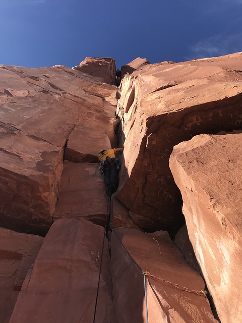
After driving half the day on Friday and most of the day on Saturday Ben and I got into Moab Saturday afternoon and went to climb Wall Street before it got dark. Climbing the sandstone of southern Utah is as similar to the granite of Washington as geography between the regions is. Crack climbing technique doesn’t change much, but unfortunately I have none of it. No matter though, we’re all warmed up now so we drove out to Castle Valley to camp at the trail head.
This was our big objective for the trip. Best to get it out of the way early so we can do other things. The third member of our team had a days head start on us but the Westfalia is actually a two day handicap so he rolled in to camp later that night. We all got up the next morning at 6am and beat the other potential climbers out of camp by 730am.
The trail heads straight up the wash from the parking lot following the cairns. Eventually it runs into a road and turns left to follow it before crossing and continuing on to the base of the tower. It took us a little over and hour from the car to gain the saddle just below the tower.
The base of the route was easy to identify because there was a team already there ahead of us. They would have served as a convenient point of reference except that they were tragically slow which meant that it was a little after 10 when we finally started climbing. The first pitch follows a great sustained hand crack up a corner. The crux of the route is a bulge at the top to pull through to reach the first belay. This was a little tight for three people.
The seconds pitch starts with a short off width section. A 5 or 6 camalot would be usefulhere but we didn’t have one. “The bolt” seems decent enough to hang on but I wouldn’t feel great about falling on it. Climbing the chimney alternates between easy climbing and pulling several committing moves. The belay uses two large pitons fixed in the rock.
The last two pitches can be link together if you mind the rope drag. We did not. Climb up and left out of the chimney then step over and across it to the far side and climb up to the notch. Climb through it and meet up with the last pitch of Kor-Ingalls.
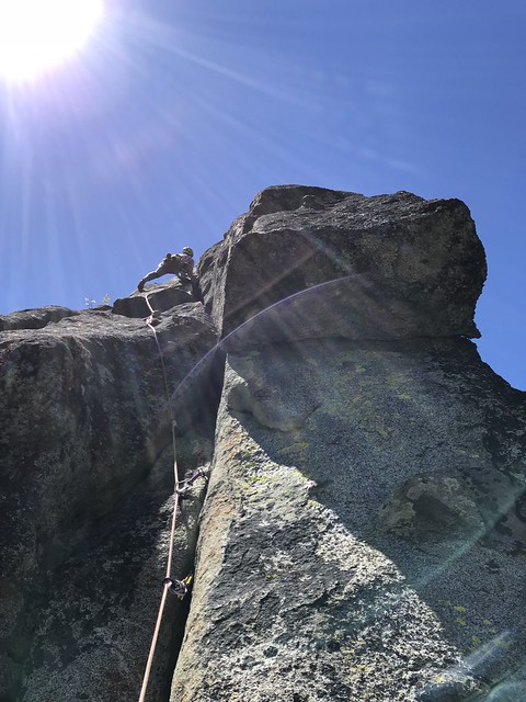
The wind was ripping pretty hard when we topped out a little after 2pm. The other group was nowhere to be seen so we hung around on top for awhile enjoying ourselves and the wind. When we couldnt take it any more we started our way down. Rappel the North Face for the most direct way back. This takes 3 double rope rappels with a 6o meter rope. Then we were back on the ground.
Located on the north end of Snow Creek Wall, April Fools Tower is one of several towers in the immediate area and constitutes a long approach, a short climb and a spectacular rappel. If your goal is to climb everything in in the area it should definitely be on your list. If your goal is to climb the good climbs in the area you can probably wait on this one.
Starting at the Snow Creek parking lot, cross the bridge and take a climbers trail to the right just after the aquaduct. Cross the river and continue up to the base of Pearly Gates. To the left of Pearly Gates wall a thin trail continues up through a loose gully to the top of the wall. From here gain the ridge in front of you by means of least resistance and continue up to ridge to a small grouping of trees where the tower will now come into view in front of you. Traverse the hillside up to the obvious notch between the tower and the hill. The climbing starts here.
From the notch move left just below the ledge and traverse around the north side before climbing up to an obvious belay ledge. (P1)
From the belay a short chimney gives way to twin cracks. Climb up to the big flake slung with rap anchors. Continue right to the chains on top. (P2)
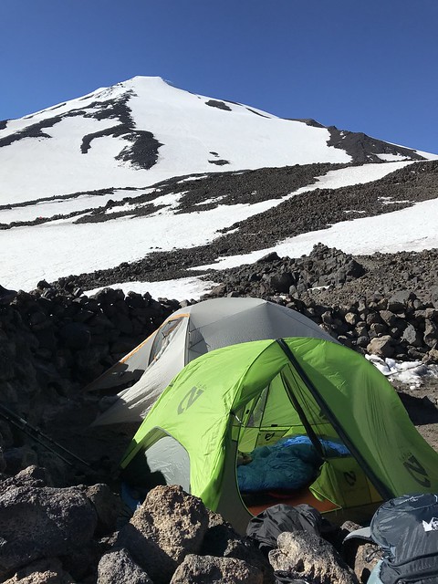
We had planned to do this one a couple weeks ago but the weather was bad. This weekend however delivered perfect climbing conditions so we trekked south for a Mt Adams climb.
Leaving Seattle on a Friday is a loosing prospect to begin with. Then there is the location of the mountain itself. It is said that Glacier Peak is the most remote volcano in Washington, but I think I would rather do a few extra hours hiking, than the five hours in the car it took to get to the town of Trout Lake. All the same, we camped out on Friday night which made for a relaxing morning on Saturday where we slept in, made breakfast, checked in at the ranger station and drove up to Cold Springs where we started out from the trail head by 11:30pm.
We stopped for lunch at 7000 ft where the snow finally became skinnable. By 2:00 pm we were moving again, making it to Lunch Counter camp by 4:00 pm which allowed for casual evening.
The next morning we were up a little after 5:00 am and on the move by 6:30 am. We topped out by 11:00 am, rode the south ridge down and were back at camp by noon. It was a gorgeous sunny June day and we enjoyed every minute of the climb crowd negotiation included. We were back to the car by 3:oo pm. The snow was soft but sun cupped and made a choppy ride down at certain points but warmed significantly from the day before. None the less it was good to check another Washington volcano of the list.