Categories
Climbing Mt Hood Touring

Mt Hood, Cooper Spur

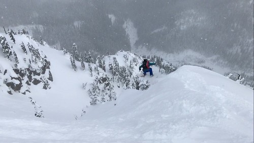
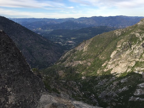
We’re standing on the top of Oregon’s tallest volcano which by itself isn’t that impressive considering over 10,000 people attempt the summit every year but our path was windy one and for awhile the whole thing seemed unlikley so for now we are just happy to be here.  The Cooper Spur route on Mt Hood doesn’t get traveled nearly as much as its cousin route to the south. The steepness of the route combined with its relative inaccessibility early in the season while Cloud Cap road is still closed, increase both the physical and technical factors.

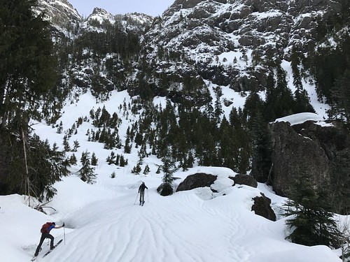
If you’re coming from Hood River the route follows the skyline up the left side of the mountain in what is obviously a desirable ski. We drove down from Seattle on Friday afternoon, stopped for dinner and started hiking by 11:15pm that night. We we’re concerned about rock fall up through the chimney at the top so we wanted to summit early before things started heating up.

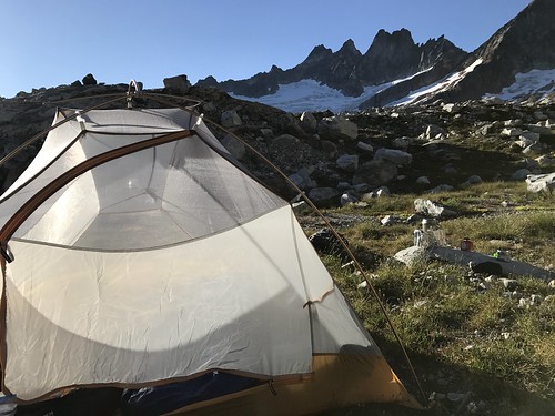
The road is currently closed at the Tilly Jane Sno Park so that added an extra 3.5 miles and 1500ft to the day. Climbed up to 8200ft by 230am and we encountered 40mph winds and low visibility so we bivied to wait for the sun to come up. It was very cold.

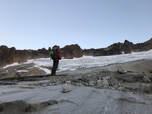
At 6am we moved camp up to the bottom of the “climb” at 9k despite continued poor viz. At 830am we decided to bail on the summit because we didn’t feel comfortable snowboarding a route that we couldn’t see.

We had dropped about 500ft when suddenly everything blew off and the weather cleared. At this point we decided to go for the summit after all so we turned back around and finished the climb.

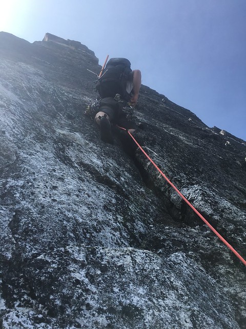
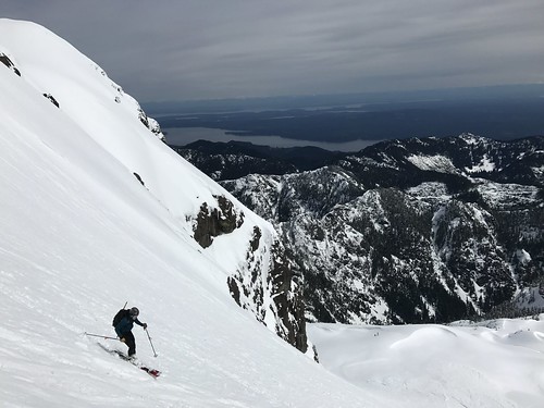
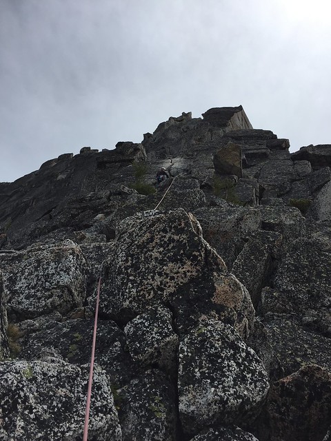
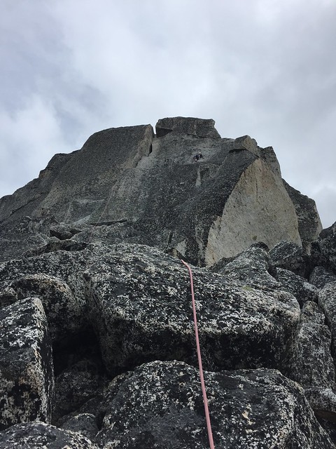
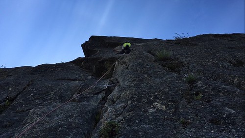
The final 2200 is a fairly sustained 50 degree pitch that requires front pointing with two tools. I only had one, so things were slower for me. The objective hazard from rock fall was mitigated by the wind keeping things cool. We opted to not rope up as an unarrested fall would have been potentially fatal for the whole team due to the exposure below.

We summited around 130pm riding the line down that we climbed. It hadn’t really softened so the top 2000 ft was fairly icy. It made for a pretty gripping descent.

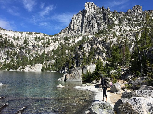
The corn skiing was decent between 9200 and 7500ft and mush after that. We got back to the car by 4pm.

It was a 17 hour day with about 11 hours actually moving. A very aesthetic natural line on the mountain with nice exposure and great climbing in that last 2k feet. It wasn’t the basic route to the summit and it wasn’t our typical climb but the results were great all the same.

Categories
Washington Touring Snoqualmie Pass

Chair Peak Circumnavigation, Alpental Valley

We went out in Alpental Valley on Saturday. For me, it was my first time out there on a splitboard. Our objective was to Circumnavigate Chair Peak.

We left from the upper parking lot at 8am and split up into the valley following the groomed track until it ended. At this point split left until we met up with the main skin track just below Source Lake.

The East Shoulder of Chair Peak was pretty crowded with groups skiing off every aspect, by the time we got up there around 10am. We dropped the north side down to Snow Lake making the best turns of the day.

The trail out the west side of the lake was set for us up to 4400ft where we bumped off of it passing the guys who had set it as they bailed off of Holy Diver due to warming conditions. After that we were on our own, breaking trail up to Melakwa Pass and then down the other side completing 3/4 of the pizza that is Chair Peak.

Finally the last sprint up to the top of Bryant Peak Couloir where we could look back down into Alpental Valley and at our last descent. The run back to the car could be made by the determined one footed snowboarder without a transition.

Warming temperatures couple with storm and snow and wind activity in the previous days caused a lot of loose wet slides on just about everywhere the sun hit. Early in the week some pretty big slides released leaving crowns upwards of 5ft on North East aspects and significant debris on our descents into Snow and Source Lakes.

Nevertheless the snow and the weather lined up very nicely for a time out in the valley

https://www.strava.com/activities/1434898096


https://www.instagram.com/p/Bf6vfvSHc0C/?taken-by=peakoftheweek

Categories
British Columbia Selkirk Mountains Touring

Asulkan Hut, Rogers Pass

I booked three nights at the Asulkan Hut after the third separate conversation when it came up last year. The hut was built in 1995  so who knows why it took so long to get on my radar but I guess I’m still relatively new to British Columbia huts so away we go, to Rogers Pass.

The long term forecast had looked nice for the weekend of our trip. A couple feet of new snow and clearing weather for the holiday weekend, but that changed as temperatures started to warm straining several already anxious persistent weak layers from earlier in the season. As we split out into the valley on Friday we passed the last two of our hut compatriots just as they were turning around unwilling to risk a weekend at the hut in unstable conditions. They mentioned that the other four folks who had also booked the hut had already bailed so just like that we had one of Canada’s best huts to ourselves.

We arrived at the hut a little before 2pm, about four and half hours after we had left the car. The sun wasn’t coming up fully until 8am and it was starting to set by just after 3pm so we called it early and saved it for Saturday. On Saturday the avalanche danger was not only high, but there was a special bulletin out discouraging backcountry travel in the region. With this in mind we stuck to lower angle runs below the hut like the tree triangle and the moraine. We triggered one slide remotely, probably about 300 meters across, going up for the last run of the day but kept it pretty safe.

More warming on Sunday and we decided to pack up and head out a day early. The temps were predicted to spike just above freezing resulting is a significant shedding cycle that we didn’t really need to mess with. We drove back to Seattle that night and promptly booked 3 more nights at the Asulkan hut for next year.

Categories
Crystal Mountain Touring

Crystal Mountain, Silver Basin

Just a quick update on early season conditions so far. We went out in Silver Basin at Crystal on Saturday. There were probably about 50 cars in the parking lot when we arrived a little after 9am. It was wanting to snow so badly while we geared up but it was coming down mostly as mixed precip.

Our group of 10 split up the Quicksilver chair line more or less in some very heavy snow that didn’t really soften until we entered the basin proper at 5600 ft. From there we followed the skin track of 5-10 other groups who were already out there attacking Three Way Peak, the King and everything in between.

We took about three runs and several core shots before we turned around at 2pm and rode back to the parking lot. Good snow up high, still a little wet, but that will help to cover some of the sharks that are still lurking up there.

More snow this week. Fingers crossed for an early opening.

Categories
North Cascades Climbing Movies

Inspiration Peak, East Ridge

This year Tim and I decided we wanted to learn the true meaning of Labor Day so while we could have spent our three day weekend climbing anywhere we chose the Pickets, a range in the North Cascades known by climbers for its remoteness and inaccessibility. In 1931 when all of the major peaks in the Tetons had established routes the Pickets saw their first recorded technical ascent. When people talk about the wild of the North Cascades they are talking about the Pickets.

So we decided on the east ridge of Inspiration Peak, a route first climbed by Becky and company in 1958. We started from Upper Goodell Creek Campground at 10am on Saturday morning. The first 4 miles follows an overgrown road bed along the east side of the creek until it abruptly ends, signaled by a cairn and turns uphill. From there it was an unrelenting 5000 ft charge uphill on what is generously called a climbers trail. But even that doesn’t tell the full story, in a place where an approach is better measured in time rather than distance. And 8 hours later we made camp following a well traveled trail into a gravel basin  at 6000 ft with a meadow at the bottom and plenty of water to make up for the lack of it on the approach. Big views of terror basin the  the southern Pickets took some of the hurt off from the approach and reset our motivation.

IMG_1284

The moon was so bright at night that I woke up and ask Tim to turn off his headlamp and I saw the big dipper sitting right on top of Inspiration Peak. That must have been around midnight. Four hours later I woke up to make breakfast and by 4:45am we were on the trail picking our way around boulders and across massive rock slabs on our way up to the glacier. We tried to follow the cairns across the outlet of a lakelet and then down and across a bigger ravine that we made note of because the scramble up the other side was a little tricky but also tough to identify from the top. (note: It may be easier to swing way up high on this one and cross over the creek around 6400.)

When we hit the glacier we roped up for some fairly straight forward glacier travel up until our final crevasse crossing. We navigated it by down climbing off of a snow bridge onto a lower ledge and climbing out. And then we stood at the bottom of the route, 7,400 ft above the ocean, four hours after we had started. We simul-climbed the first “two” pitches following a series of gullies and ledges trending toward a notch between the east ridge and a small spire to its right. The climbing gradually turns into a blocky face that we broke out into two 5.7 pitches as we worked our way onto the east ridge.

IMG_1292

The next two pitches are the ones we came all the way out here for. The layback pitch starts exactly how it sounds climbing right around the roof and then straight up to a roomy belay at the bottom of a splitter hand crack. The crack climbs straight up and offers the occasional face hold but mostly excellent hand and foot jamming. At the top we cut out right aiming at the notch in the rock around the roof and then up and left to a belay.

IMG_1340

Now through the crux we simuled the last “three” pitches to help ease the rope drag on a wandering climb across the top. From above the hand crack drop on to the north side and then up and left and around the south side of the east summit. We crossed the ridge down climbing to the base of the True summit and then and easy low fifth class scramble all the way up checking in at the top at 4pm.

Now the good part. Three double length rappels down the West Ridge. Raps are easy to find. Three more double length rappels down the gully. Lots of loose rock with very little protection offered from above. This took us 3 hours. Then we were standing at the upper glacier trying to figure how to cross a massive moat to get up on top of the snow. As it was, we climbed down underneath the glacier through a tunnel and popped out on a ledge in a crevasse. It was dusk now and we were loosing light, so with no great option to get out we front pointed straight up and out which was a less desirable approach with a lot of exposure to what lay below but ultimately better than turning around and finding another route out in the dark.

IMG_1336

The rest of the trek back was long and circuitous in the dark, but generally uninteresting. Back at camp at 11:30pm. We had stashed a couple beers in the creek that made the hike back slightly more bearable and made dinner slightly more enjoyable.

Slept in on Monday but the smoke came in that night to punished us in the morning and then on out hike out. We made it back to the car in 6 hours. It doesn’t get much more Cascades than this. It may take awhile to forget the approach and head back into the heart of darkness that is the Pickets but we did well in honoring the holiday.

The rest of the photos

https://www.instagram.com/p/BZB8-RtA7av/?taken-by=peakoftheweek

Categories
Olympic Mountains Touring Movies

The Brothers, East Basin

Looking west from Seattle, The Brothers rises up from the sound to 6650 ft. The East Basin is the obvious line from the top and even from 40 miles away is clearly a sicky.

After a very wet March and April with few breaks in the weather, Easter Sunday was forecasted for sun so we camped out at the Lena Lake trailhead the night before and hit the trail at 4am for what would be a 14 hour day. The first 3.5 miles were in the dark, we reached the lake at 6am. From there the hike slowed with with several broken bridge crossings and a bit of route finding up the Valley of Silent Men.

IMG_0626

When we reached the climbers camp a little after 8am we had enough consistent snow to finally get the boards off our backs and transition to splitting. We crossed over to the west side of the creek almost immediately and traveled until we broke out of the trees into the basin. Now we had to deal with some difficult travel conditions in steep brushy terrain and sloppy snow, a lot of which had shedded into massive debris piles during the previous rain cycle.

IMG_0642

At 5000ft the travel eased up and it was smooth sailing until 6400ft where we switched over and boot packed to the summit, topping out at 1pm. The descent was fast then slow, beginning with spring powder conditions then warming into a mush near 5000 ft.  The basin itself is huge and paired with the numerous bulges, windlips and steep chutes that filter into and out of it, it offers a ton of rad skiing opportunities. At 3400 ft we switched back to skins until it was time to put them on our back and make a break for the car.

IMG_0652

We ended up back where we started at 6pm rounding out the trip with some Milano cookies and a couple beers. I think we’ll be looking at this one for a long time once more until we decide to go for it again.

Categories
Touring Movies

Wendy Thompson Hut, Marriott Basin

Another year, another hut trip. 2017 was the Year of the Coast Mountains in British Colombia. The Wendy Thompson Hut was nearly booked full when we decided to make reservations in late summer but we managed to score 5 days in for the beginning of March and score we did.

Wendy Thompson Hut Trip - March 2017

After a drought that seemed to last most of January and February with a few exceptions, the snow returned in a major way the week before our Saturday departure and dropped nearly 3 ft around the Duffy Lakes area and then cleared allowing a mostly sunny tour in. 4 miles and 2000 ft put us at the front door of the hut right before the clouds came back in for another storm that brought us snowfall for the rest of our trip.

Because of the recent and continuing snowfall we kept our objectives fairly conservative for the entirety of the trip, venturing into steeper terrain only a handful of times and when we did it was brief. Our use of extreme caution was rewarded with no accidents, blower powder and collective hours spent in the white room.

Wendy Thompson Hut - March 2017

We managed to ski safely and that is significant, when you consider the high avalanche danger bulletin that was in effect, combined with a fatality that weekend in the greater area. The snow was definitely wanting to move while we were out and while one couple in our group did manage to break off a sizable slab about 18in deep and a few 100 ft across on the first day, we all managed to keep our noses clean.

Another one for the history books, time to start planning for next year.

Photos Courtesy of Brian Behrens

Categories
North Cascades Mt. Baker Touring

Mt Herman, Stoneman Couloir

Alright! Time to break the long silence with the first snowboard trip report of the season. Did you miss us?

IMG_9820

We went up Table Moutain and Herman a couple weeks ago but it didn’t quite warrant a write up. Fast forward to today and once again we were heading out of the upper lot at the resort around 9am. The snow around Bagley Lakes has been hit hard with tracks since the last storm but was holding up great with the cold temps in the last week.

We headed toward the high saddle that splits Bagley Creek from Mazama Bowl where we found deep consolidated powder on E and SE facing slopes. Dropping in off Mazama Dome we found much looser unconsolidated but mostly stable snow on N and NW aspects that made for some killer turns but difficult uphill as we transitioned and made the approach to the saddle below Herman proper.

IMG_9854

From there it was a boot pack traverse out to the top of the couloir where we made the transition at 11:30am. While we were not the first to ride Stoneman Couloir on this last storm cycle, it hardley mattered as there was plenty of room for everyone and the snow was deep and light. At the bottom we traversed left above the trees to a smaller tighter couloir that starts at about 5300ft.

IMG_9855

Now to find a way out.. From 4800ft the exit down to Bagley Creek either requires a hard cut right or a hard cut left. We tried to split the difference and ended up on a cliff band that required some trickery to get down. Next time I will opt for the honest line. In the end we made it out arriving back in the Heather Meadows parking lot a little before 2pm.

Check Stoneman off, and then add it back on the list. This one is a classic!


More photos courtesy of Corbin Hudacek here

Categories
Climbing Stevens Pass

Prusik Peak, West Ridge

The great debate, skiing vs snowboarding, Hillary vs. Trump, is OJ Simpson innocent? And then the big one; to approach Prusik Peak from Snow Lake or from Colchuck Lake. Certainly there are merits to both but in this increasingly partisan world, people have picked their approach and climbing teams all over the Northwest and beyond have been ripped apart by their inability to see the other side.

On one hand you have Colchuck Lake; less mileage and slightly less elevation but a grueling climb up Asgard Pass gaining 2200ft in less than a mile. On the other hand Snow Lake; nearly 6 miles longer but a much more gradual elevation gain, a well marked trail and significantly less snow and ice this time of year.

Fortunately Whitney and I are rarely consumed by such mindless bickering so after weighing our options carefully, I won and we went from Snow Lake.

IMG_8198

Personally, I wasn’t keen on trying to tick this one off in a day, but we didn’t like our chances for getting a permit in the Core Zone so Whitney suggested we just go for it. So we did, starting out from the trailhead at 5:15am. The spillway at Snow Lake was running about ankle high when we crossed at 8am, stopped at Lake Viviane for an early lunch and made the turn off to Prusik Pass at 11. From here the trip gets better.

IMG_8200

The snow is patchy beginning in the upper lakes becoming fairly consistant by the time you hit Perfection Lake. Trying to find the high point on Prusik Pass we lost the climbers trail in the snow and started on the route a little early. In this way we got an extra pitch in on some mossy rock that wanted climbing. No doubt we are not the first climbers to climb this desperate crack. From there the climb was as follows.

Pitch 1

The longest pitch, it ran through just about all 70 meters of the rope but its fairly soft climbing trending left until you hit the ledge.

IMG_8209

Pitch 2

This one was a quicky. You jump over to the north side and up a short slab until you hit the piton and slingable block right before the crux.

Pitch 3

The crux is really only 3 frictiony moves that feel exposed because theres nowhere to protect. Whitney clipped the piton and pulled the crux like a pull tab. From there, climb high and right traversing the south side with excellent exposure, until you hit the notch and then back over to the north side. Communication was a little tough here and rope drag was bringing us down so we stopped to belay.

IMG_2698

Pitch 4/5

From here you scoot out onto a series of wide ledges back on the north side. They can really just be done as a casual scramble to set you up at the bottom of the final pitch. This is where the climbing gets really jazzy. Climb up a dihedral on the left then move right to a big lay back flake. We skipped the obvious wide crack directly above and instead climbed right around the corner to two smaller chimneys to make the summit at 4pm.

IMG_8215

From the top it is 5 raps down the north side to the base. We traversed back around to where we stashed our gear at the start and were on our way out by 530pm.

IMG_2706

We hit Snow Lake at 8pm. Nada Lake at 830pm. Car at 1050pm. The last couple miles were dark and pretty slow. A brutally long day but an absolutely classic climb, for hotdog and hamburger lovers alike. Next time we’ll try it from Colchuck.

Categories
Climbing

Snow Creek Wall, Outer Space

What originally was planned as a weekend mission out to climb Leavenworth, became a day trip to do Outer Space when the weather went sideways. Turns out we missed a nasty day on Saturday too. The guy at the shop in town said “it just doesn’t rain like that here often”. However by Sunday it had all blown through so we cruised out there to take advantage of the second longest day of 2016.

We left Seattle a little after 8am arriving in the Snow Creek parking lot about 1030am. We were on the trail by 11am. It took us about 50 min to get to the cut off to cross Snow Creek. The trail cuts left after crossing the creek, goes over some logs and then joins a well worn path up the hill to the base of the wall. We skipped that though, in favor of a bushwhack up the right side until we got worn out and traversed over to the base of the route.

IMG_8132

There were probably 3 or 4 teams on the wall when we arrived but it moves fairly quickly and we didn’t have to wait long to get going. We started on the Remorse variation, to the left of the vegetated gully. It sort of just meanders left until you hit the ledge just within earshot and almost a full 70 meters of rope out. From there the second pitch climbs the ramp to the right straight up the the Two Tree ledge and joins with Outer Space proper.

IMG_8128

From here we found our groove and knocked off the crux pitch up to the short pedestal ledge where we sat and thought about climbing while we let a couple of faster local dudes pass us. They were nice about it though and despite going ahead, they left some rock for us to climb.

From there it is two pitches of a steep, splitter hand crack to the top. The crack is only interrupted once at the start of the final pitch with a bit of a tough move, stepping left off of the belay ledge and using a finger crack and a couple of far left knobs.

IMG_8113

We topped out a bit before 7pm and rushed down to beat the light. The walk off sucks big time but it is well marked so I guess whatever. I think we were back at the base of the wall by 8pm and back at the car by 930pm. Over all a great climb, a classic route and a very long day.

IMG_8121