Peak of the Week is back! And after a considerable hiatus. The adventures never actually stopped, the motivation to write about them stalled out for a bit. It was temporarily.
This year we wanted to utilize a long holiday weekend on the 4th of July for a long holiday climb. Our plan was to try the Northeast Buttress on Mt Goode in the North Cascades. We would go in via Bridge Creek at Rainey Pass, carryover on the climb and exit through Stehekin taking three days for the trip.
Mt Goode is characterized by its remoteness within North Cascades national Park with it’s NE buttress being one of the longer technical ridge climbs in the state.
Campers were lining up at the Marblemount Ranger Station for overnight permits when I pulled into the parking lot at 6:50am on Friday morning. Covid restrictions had the park operating with just one permitting station at a time causing a decent amount of irritation. Despite all of this, 3 hours later when they finally called my ticket number still no one had requested a permit within the Goode back country zone. Although we anticipated something close to that, it was also telling.
From there we drove the the Bridge Creek trail head just over Rainey Pass, and finally started our hike at 11:30am. Tim’s folks, Clay and Chris saw us off for the first 6 miles of the trip until they turned off at the the South Fork and we continued on our way. Crossing a suspension bridge at Maple Creek, turning north up the north fork toward Grizzly Creek Camp.

Here the brush got a lot thicker as this trail does not see as much use. We spent a few minutes searching for a suitable creek crossing over Grizzly Creek and finally cut off the trail after a few more miles to cross the North Fork to start up the south side of the valley.
It was about 6:00pm at this point an we had been setting a fairly speedy pace covering about 16 miles in 6.5 hours but now we had 2000 feet of elevation to climb and not even a hint of a trail to do it on. The climb up to camp is a bit of a dealers choice with a little bit of everything and a lot of tearing through various stands of slide alder. A snow apron down low helped to mitigate some of the hard travel early on but once we cut right to navigate up, through and above the slabs the brush closed in on us delivering a classic North Cascades experience for the next 1200 vertical feet.
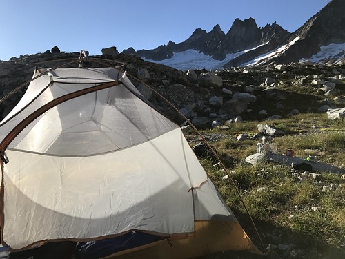
The terrain is steep below the glacier and once you leave the creek down low you can count the number of level spots suitable for even a small tent on a couple fingers. We found one at 5200ft and squeezed two tents on to it comfortably, finally dropping our bags for the day at 7:45pm.

Night 1 camp 
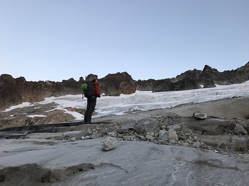
Looking up at Goode from the North Fork
The next morning we were up by 5:30am, packed up and moving by 7am. The slabs below the glacier made for some enjoyable 3rd and 4th class scrambling until we ultimately roped up for the glacier crossing.
The glacier itself was in good shape with minimal hazards. Even moving from the glacier across the moat and onto the ridge at 6800ft was a straightforward experience. Now it was time for the main event. Stow the ice axe and crampons and pull out the climbing gear.

We had expected sunny weather for our climb day, however when we woke up in the morning the top of the mountain was obscured by clouds. As we climbed the clouds did as well, all the while offering a cooler day.
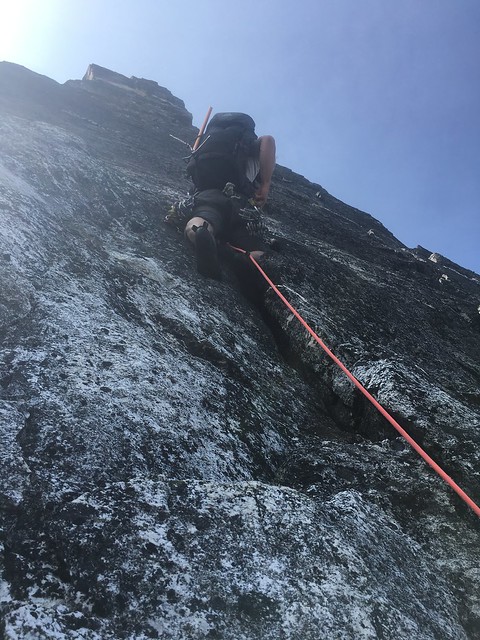
The first bit of climbing offers some reasonably steep moves before turning the corner and moving up onto a slab. From here we stayed more or less true to the ridge for the next 1500 ft moving through a variety of gniess ranging from 3rd to low 5th class in its grade, ultimately touching 5.5 for the last few hundred feet directly below the big ledge at 8600ft. This is where we decided to settle for the night.
I find these long ridge routes often feel deceiving because it can be so hard to judge your progress against the ridge itself. You spend hours climbing with seemingly little to no progress made toward your objective. After climbing for 8 hours that day we were ready to give it a rest as soon as we found a suitable bivy and the ledge proved to be that. Room for a couple tents, plenty of snow to melt for water, a perch that offered views in three different directions and for the first time on our trip the clouds had finally burnt off giving us a spectacular sunset. At 6:00pm we had the rest of the evening to enjoy it.
The next morning the clouds were gone the sun was out and it was time to finish the thing off. We anticipated about 3 more hours to the top at 9,199, so we packed up and hit the gas. Were we had spent most of the previous day simul-climbing it seemed easier to pitch out the remainder of the ridge. The climbing and steepened up a bit and was pretty steady mid 5th to the summit.


The big ledge 
Sunset
We topped out at 10:30am on a gorgeous sunny Sunday, July 5th. From the summit you can see every major peak in the North Cascades and an overwhelming number of the minor peaks as well. Goode has a feeling of sitting directly in the heart of the region. We lingered just long enough to take a selfie before hurrying to start the process down. Our intent was to make it to Stehekin that night where we had booked a room at the landing and we had some serious ground to cover ahead of us.

Two rappels back down the way that we came puts you on a thin ledge that traverses around to the south side of the mountain to a notch at the top of the South East Couloir. This is the descent, more or less a straight shot of -5200 vertical ft to Park Creek.
Rappels turn into scrambling, turned into glissading, turned into down climbing and finally into a bushwhack through first burnout and then a sea of sword ferns until we finally a hit trail again at 6pm. It was the first trail we had seen in 2 days and now we had 12 miles to go on it before we had any hope of our day being over.

The pace into the Stehekin Valley was quick and we raced the sun as it set toward night time. The 12 miles we still had to cover was just to get to the upper valley where the road meets the trail at High Bridge. Past that is still another 12 miles to reach the landing at Lake Chelan where we had reserved a spot for the night. We reached High Bridge at 9pm, took inventory of our situation and decided the only option was to keep walking. (Often there is a shuttle that operates on this road but we were well past its sechduled hours) After about 5 miles on a dark empty road in the woods a car slowed as it passed and offered a ride for the remaining stretch. We enthusiastically accepted and thus finally ended our long trip.

What a climb! It had all of the characteristics of a Cascade adventure. Soggy weather, remote setting, loose rock, route finding, glacier travel, engaging climbing, spectacular sunsets, berry pies at the bakery and a good group of climbing friends. I know it’s early but it may be time to start planning for next years trip.