Categories
Climbing

Prusik Peak, South Face, Beckey-Davis

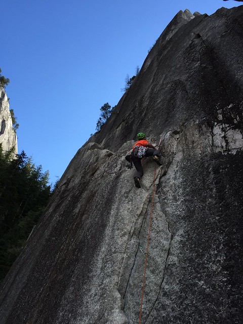
The reviews are in, Prusik peak is as good as they say. Chase and I climbed it last Thursday (7/20) via the Beckey-Davis route on the south face. I would summarize the route as sustained alpine granite fun. The following is a summary of approach/descent and a pitch-by-pitch recap of the climb. Hopefully this helps the next aspiring Beckey wannabe find their way up the route.

Approach – we started from Snow Creek TH at 4:30 AM, got to lake Viviane by 8:30 AM, filled up our water bottles, and maneuvered around the east side of the lake to the base of the climb. We started climbing around 9:30 AM.

Pitch 1 – The Chimney (5.7), probably the least enjoyable pitch of the climb. Just general awkward stemming up the thing, good pro though. If I were doing this again I would go up the 5.8+ wavy crack to the left of the chimney, it looked more enjoyable and you can traverse over

Pitch 2 – (5.7?) We went far right from the belay ledge above the chimney and got into some face climbing and hollow flakes. Not great.

Pitch 3 – (5.7) This is where the climbing gets good and the exposure starts. fun blocky climbing to your pick of belay ledges. This pitch would be easy to pass a party if needed. We didn’t have anyone else on the route with us.

Pitch 4 – the Traverse (low 5th) – traverse down a steep step, then up another steep step to a tree belay, now you’re at the base of the crux pitch, but you could climb another 10-15 feet if rope drag is managed.

Pitch 5 – the Crux (5.9) – super fun and positive laybacking in a right-facing corner, then a left facing corner which ends us getting really hard, at which point you have to make a step across to the left and easier climbin. Great pro. This route just eats big pro (1 to 4).

Pitch 6 – (5.7) fun climbing to the “notch” at the base of the true north summit.

Pitch 7 – (5.7) a low-angle ramp on the north side of the peak will take you to the top! the 10a variation looks fun too but we were worked.


Descent – Descend via the north face rappels (took us ~6 rappels with a single 60m). Then its a quick walk around to the base of the west ridge and one more rappel gets you to the south face. took us 2 hours from summit back to packs. Then a long walk back to the car. All in all is took us 21 hours car to car. Fun and exhausting day capped with Tim’s Jalapenp chips, the best there is. Great climbing Chase!


Categories
Washington Climbing Touring Mt. Rainier

Mt Rainier, Success Couloir

Success Glacier Couloir on Mount Rainier. A friend of a friend had heard about it.

Finding information on the route wasn’t easy; a google search pulled up a couple dated trip reports with helpful beta but very little to cross-reference against. Skiing down the south-facing couloir seemed straight-forward (and fun!) but climbing up was more like choose your own adventure. We chose the Kautz Cleaver for the ascent with two goals in mind: 1) ski the couloir, and 2) summit rainier via a traverse onto the Kautz Headwall.

We (David, Sam, myself) started Saturday morning from Paradise at 9:30 AM. Day One was largely a traverse taking us across the Nisqually, Wilson, Van Trump, and Kautz Glaciers. The route steepened when we got to the cleaver (35 to 45 degrees) and we ascended to 10,200 feet before taking up camp at a lovely bivy spot. For some reason this route just isn’t popular with the rainier masses, so we had the entire cleaver to ourselves Saturday. Party! A couple flasks were downed and the three of us retreated to the tent to rest up for summit day.

IMG_0864

We continued up the cleaver Sunday morning at 5 and by 7 the sun was hitting most of the route. This proved to be a big problem; around 12,000 feet we started getting hit by ice pellets, which turned to ice balls, which turned to rock, one of which flew right over my head. Good karma? Bad karma? Damnit. The reality had sunk in. Our timing was off, conditions weren’t right. The good news was we were nearing the top of the couloir. The bad news was if we wanted to summit, we still had an exposed traverse over the Kautz underneath a rimy, rocky, ridge that was also likely unloading its contents onto the slopes below. A fall would be “a bummer” in the words of David Kiker. Agreed, David.

We made the safe call to fold our hand on the summit bid and focus on the ski/board down. After a quick nap at 12,800 feet, we headed down. Snow was firm up high, with some packed powder turns, turning to corned snow between 12,000 and 9,000. We did not observe any loose wet avalanches on the way down, although the snow got very rotten around 7,000 as we descended via the Van Trump, down through comet falls and eventually onto the hikers trail. This is a fun tour that is highly recommended over two days; great steep skiing and an isolated feeling.

IMG_0916

Categories
Climbing

The Chief via Squamish Buttress

Turquoise water was white-capping on the left as a massive chunk of granite came into view on the opposite side of the road. The thousand foot walls of grey granite occasionally streaked black with lichen stood proud over the valley. This is bigger than I remember, I thought to myself. Or maybe I was just looking closer this time…

It started as it always does, with mutual acknowledgment of an open weekend and an ambition to get after it. We were looking to climb rock after a relatively low-key August. David was still riding high from his previous trip to Squamish, and I heard good things, so it was decided we would head north.

One of the most challenging aspects of climbing in Squamish is picking an objective. By some counts there are over 1,500 established rock climbs in the area. Each one has something unique to offer. Friends say do this, locals say do that, everyone says you can’t go wrong. Naturally, David and I coalesced around the most ambitious climb within our reach, the North Face of Squamish Buttress (a.k.a. Butt Light, The Butt Face). The 15-pitch climb would take us up a mountain known as The Chief by linking up multiple rock routes.

squamish_butt_overlay

Approach – We left Seattle on Friday afternoon, made a “quick” stopover in Bellingham for beers/ tacos/margaritas, and cruised into the Stawamus Chief campground at midnight. Sleep would be advised but David handed me a Kokanee (or two?) and we passed out closer to 1 AM.

We woke up at 7 AM and drove a couple minutes to the parking lot of the base of the Chief. After a coffee and energy bar, the time to leave was upon us. A quick, 10-minute scramble had us at the base of our first route, Deidre.

Route 1 – Deidre

Pitches 1 & 2 – The warm up. Both pitches were straight-forward slab climbing. 5.6/5.7

Pitch 3 – The going gets good. I lead a 25-meter pitch up a dihedral layback, very aesthetic! 5.8

Pitch 4 – David puts in a lead continuing up the dihedral. He starts bringing me up. DANGER! FALLING PHONE! Crap. The zipper on my soft shell Mountain Hardwear pant busts and my iPhone pops out, careening down the granite wall. A couple parties valiantly try to reach out for it but are unsuccessful. RIP. 5.8

IMG_8709

Pitches 5 & 6 – I lead the easy 5th pitch. David takes us to the end with an awkward move up to a tree belay. Both pitches were hard to protect. Not inspiring. 5.6, 5.8

We topped out on Deidre, but I was feeling low. Aside from pitches 3 and 4 it wasn’t very fun. The climbing was run out at times. It would only get harder from here, too. I suggested we go back to the car and find other, less committing stuff to climb. David was cool with it. We started our walk down when David pointed out the rest of the route up The Chief harmlessly saying “we’ll get it another time…” I took one look and changed my mind. Nah, let’s go for it!

Route 2 – Boomstick Crack

Pitch 7 – Boomstick crack was super fun. Still not sure I climbed it right with my hands in the crack and my feet smearing, but boy was it good. Belayed David up from the second tree. 5.6

Pitch 8 – Not needed. David went 10M up to another tree belay. I recommend linking these two pitches.

Between Boomstick and the next pitch on Squamish buttress is a well-worn path through the “Enchanted Forest”. This offered a nice reprieve from the wall for 10 minutes of walking.

IMG_8724


Route 3 – We are on it now, Squamish Buttress

Pitch 9 – Start spicy with an unprotected roof move followed by a face climb. Protection leaves something to be desired here. Drink your first beer. 5.8+

Pitches 10 through 12 – Continue generally up the ridge. The climbing is straight-forward. Nothing much to say. Low 5th

Pitch 13 – Where the wall gets vertical you have to traverse left into a gully system on the north face of the buttress. This pitch is a classic; lots of exposure but great protection. Finish on some ledges and a bolted belay station. 5.9

IMG_8732

Pitch 14 – Thank god for David. I was tired, arguably shook at this point. I asked him to lead the chimney pitch, which is the other crux of the climb, and he nailed it. He made an awkward roof move look like icing a cake. A little here. a little there. 5.8+

Pitch 15 – Zig zag to the top out on easy ledges.

In total it took us about 9 hours up. An easy walk down and a couple beers at the parking lot and life was good again. I’m proud of David and myself for knocking this one out, when we could have easily given up. On a related note, I’m moving to Squamish.

IMG_8763

Categories
Climbing Touring Mt. Rainier

Tatoosh, Unicorn Peak

At a certain point in early Spring, as the weather begins to warm and the sun makes more frequent appearances, us peakers find ourselves with a dilemma: should we keep ski touring or jump to the rock? But with the snow pack still deep and the sun shining strong for the last day of March – Andrew and I shot back – “why not both?”

Unicorn Peak would fit the criteria. The largest mountain in the Tatoosh Range is just a stone’s throw from Mount Rainier. It has great road access, good vertical for skiing, and a summit block that would help shake off the climbing rust.

We left Seattle at 6:30 AM and arrived at the parking lot (Narada Falls) at 9:00 AM and started our tour along Stevens Canyon Road. It is mostly flat as you pass some lakes on the left (Reflection, Louise) and the turnoffs for Castle and Pinnacle Peak on the right. After 2 miles on the road you will get your first view of the objective – Unicorn Peak.

IMG_0106

**Unicorn shrouded in the clouds**

After 3.5 miles on Stevens Canyon Road, we picked up the Snow Lake Trail. The Snow Lake Trail took us to… Snow Lake, at which point we observed significant wet-loose activity from the previous week’s warming trend. Be careful here as there are slide paths all  around the lake; I would caution against coming here with any major instability in the snow pack.

IMG_0115

**Wet loose slides above Snow Lake**

At this point the route becomes fairly straight-forward. We headed toward the gully above the lake, which spits out into a breathtaking ski bowl with 180 degrees of good skiing aspects. Shot on time, we then moved east toward the saddle between Unicorn and the unnamed summit to the southwest. The top of this is the steepest section of the tour; thankfully we had Andrew to lay it down.  Dude is a hoss.

IMG_0118

**Beast Mode Powers**

Once we topped out on the saddle, it was a ridge walk to the Unicorn summit block. At this point we got the rock gear out and made for the true summit. We took the direct 5.6 variation. It required 4 pieces of gear. There is various webbing tied to a tree at the top which you can use for an anchor. BEWARE: as I was cleaning the route, I stepped on a 2′ x 2′ boulder which completely gave way. The rock here is very porous. Actually it’s worse than that, it is disintegrating.

IMG_0126

**Andrew rappelling summit block**

We topped out at 2:00 PM, took some pics of Rainier behind our athletic, sculpted bodies, and rappelled down to the skis. We skied the line we came up on and it was gorgeous. Soft, carvable corned snow all the way back to Snow Lake where we put the skins back on and made haste for the car.

IMG_0130

**Andrew clicking in at the top**

IMG_0137

**Almost makes you want to ski…. almost**

All in all, a great day with great company, dilemmas be damned.

Categories
Touring

Hvannadalshnúkur, Iceland

There’s really no “starting in the dark” when it’s spring in Iceland… Case in point.

So we started in the light at 3 AM from Vik, Iceland with the goal of crushing the country’s highest peak, Hvannadalshnúkur.  Side note: please don’t ask me how to pronounce this or literally any other Icelandic word.

We got to the trailhead of the standard route (Sandfell) at around 5AM.  The trail starts low at ~100 feet above sea level, i.e. Bainbridge Island hiking. It is easy to find the trailhead, and it starts off with glitz and glamour as it winds its way up a little waterfall and into the first valley. The trail was bare, loose gravel up until ~1500 feet when we rose above the first valley and onto the snowfield where we saw some casual, minor wind.

Minor Wind

Luckily the wind died down for us at the exact moment I took that picture and we headed up the first snowfield.  We were the only skiers/splitboarders on the mountain that day as it was filled with a variety of walking, guided groups.   One of the guides even asked if he could buy my board off of me later in the week… apparently there is a shortage of splitboards in Iceland?  #raiseawareness #icelandsplitboardshortage

From there it was one long, straightforward slog all the way up to the volcano crater, with the Kotarjokull glacier on the right and the Falljokull glacier on the left.  No rope is needed on this section but I have a pro tip: if you’re getting tired of carrying the rope, take it out of your backpack and tell the group “I think it’s about to get sketchy.”  After 5 hours of uphill, we reached the crater and steered left toward the summit.  Akin to the volcanoes in the PNW, the crater here is huge!  It took an hour just to cross it… then you still have to go up.

Summit

The true summit only took 30 minutes up to complete.  We had the whole thing to ourselves after smokeshowing the other parties and setting the line for the day. Congrats team (Calvin & Clay).

Summit #2

The way down was marred by a broken telemark binding (yes, I’m told it is still a sport) and some white out conditions.  But don’t get it confused, this is DEFINITELY a mountain you want to bring skis/snowboards.

We finished with two Icelandic beers… each.  Nailed it. Check out Einstok and Vífilfell for a tasty beverage next time you’re in the neighborhood.

Final measurables were: 17 miles, 7,000 feet gain, 11.5 hours, lucky weather.